Towards the large-scale riverine transport of nutrients
Contact: Stefan Hagemann, Alberto Elizalde-Arellano
The Hydrological Discharge (HD) model represents lateral flows at the land surface and processes within the river. It has been validated and applied in many studies since the publication of its original global 0.5° version (Hagemann and Dümenil 1998). Recently, a new version has been developed that can also be applied globally at a 5 Min. (~8-9 km) resolution (Hagemann et al. 2020). The HD model has been coupled to several global and regional ESMs (cf. Hagemann et al. 2020). With respect to CLICCS activities on the riverine transport of nutrients, a technical framework for the transport of bio-geochemical constituents in rivers has been implemented into the HD model to make it suitable for respective current and future developments. Within CLICCS, two studies have been conducted that separately considered the riverine transports of nitrogen and phosphorus.
Nitrogen
We extended our hydrology models, the HydroPy (land surface hydrology) and the HD Model (river routing), to not only transport water but also nitrogen. HydroPy (Stacke and Hagemann 2021) is a global hydrological model and the successor of the MPI-HM model (Stacke and Hagemann 2012). The latter has contributed to the WATCH Water Model Intercomparison Project (WaterMIP; Haddeland et al. 2011) and the inter-sectoral impact model intercomparison project (ISIMIP; Warszawski et al. 2014). In our model system, it represents storage processes and vertical fluxes at the land surface within every model grid box. In addition to water, we now account for several nitrogen processes like fixation, plant assimilation and denitrification on the land surface.
In order to simulate river runoff and riverine nitrogen flows, the modified HydroPy-HD model system was setup on the global 0.5° grid and forced with meteorological data from the GFDL-ESM4 model provided by the ISIMIP project (Lange and Büchner 2021). Simulations were conducted for the historical period and three SSP scenarios. In addition, we utilized data on current and future atmospheric deposition (https://esgf-node.llnl.gov/projects/input4mips/), land use and fertilizer application from the Land-Use Harmonization 2 dataset (LUH2; Hurtt et al. 2020). Hence, we included the effects of different socio-economic pathways with respect to climate change, land use change and fertilizer application in future projections. First results show that globally we simulate the riverine nitrogen flows into the ocean with a similar magnitude as compared to observations.
Phosphorus
A new scheme to simulate phosphorus (P) transport has been introduced based on the tracer transport framework of the HD model and a nutrients dataset of the IMAGE model (Beusen et al. 2016). A new parametrization was developed for P losses from croplands based on nitrogen application and cropland area distribution from the LUH2 dataset. Concentrations for wastewater, natural land, and pasture areas were transformed into urban, forest and pasture areas using corresponding land use types from LUH2. P loads from the weathering process are implemented using a scheme of Hartmann et al. (2014). The atmospheric P deposition is considered constant (Berthold et al. 2019).
The HD model was applied at 5 Min. resolution over Europe using hydrological forcing from the HydroPy simulations mentioned above. Then, the total P discharged into semi-enclosed European seas has been assessed and trends of P losses in different socio-economic scenarios (SSPs) have been analyzed (Fig. 2). The total P load discharged into the Baltic Sea and North Sea accounts for approximately 26 and 72 kt/year, respectively, of which approximately 45% and 25% come from small catchments (those catchments with rivers contributing less than 1.5% to the basin total).
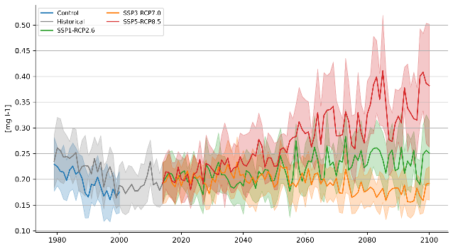
Fig. 2: Total P concentration scenario time series for rivers discharging into the North Sea. Solid lines represent yearly averages and shades the yearly standard deviation of each time series. The negative trend at the beginning of the historical period is due to the agricultural water pollution reduction policies established during the 1980s. Note that SSP3 assumes a regional competition scenario, where most industrialized countries around the North Sea and Baltic Sea experience a decrease of population which in turn reduces crop, pasture and urban activities (Riahi et al. 2017), thereby decreasing the amount of P losses into the rivers.
References:
Berthold, M., Wulff, R., Reiff, V., Karsten, U., Nausch, G., Schumann, R. (2019). Magnitude and influence of atmospheric phosphorus deposition on the southern Baltic Sea coast over 23 years: implications for coastal waters. Environmental Sciences Europe, 31(1), doi: 10.1186/s12302-019-0208-y
Beusen, A. H. W., Bouwman, A. F., Beek, L. P. H. V., Mogollón, J. M., Middelburg, J. J. (2016). Global riverine N and P transport to ocean increased during the 20th century despite increased retention along the aquatic continuum. Biogeosciences, 13(8), 2441–2451, doi: 10.5194/bg-13-2441-2016
Haddeland, I., Clark, D. B., Franssen, W., Ludwig, F., Voß, F., Arnell, N. W., Bertrand, N., Best, M., Folwell, S., Gerten, D., Gomes, S., Gosling, S. N., Hagemann, S., Hanasaki, N., Harding, R., Heinke, J., Kabat, P., Koirala, S., Oki, T., Polcher, J., Stacke, T., Viterbo, P., Weedon, G. P., Yeh, P. (2011). Multimodel estimate of the global terrestrial water balance: Setup and first results. J. Hydrometeorol., 12, 869–884, doi: 10.1175/2011jhm1324.1
Hagemann, S., Dümenil, L. (1998). A parametrization of the lateral waterflow for the global scale. Climate Dyn, 14 (1), 17–31, doi: 10.1007/s003820050205
Hagemann, S., Stacke, T., Ho-Hagemann, H. T. M. (2020). High resolution discharge simulations over Europe and the Baltic Sea catchment. Front Earth Sci, 8(12), doi: 10.3389/feart.2020.00012
Hartmann, J., Moosdorf, N., Lauerwald, R., Hinderer, M., West, A. J. (2014). Global chemical weathering and associated p-release — the role of lithology, temperature and soil properties. Chemical Geology, 363, 145–163, doi:10.1016/j.chemgeo.2013.10.025
Hurtt, G. C., Chini, L., Sahajpal, R., Frolking, S., Bodirsky, B. L., Calvin, K., Doelman, J. C., Fisk, J., Fujimori, S., Klein Goldewijk, K., Hasegawa, T., Havlik, P., Heinimann, A., Humpenöder, F., Jungclaus, J., Kaplan, J. O., Kennedy, J., Krisztin, T., Lawrence, D., Lawrence, P., Ma, L., Mertz, O., Pongratz, J., Popp, A., Poulter, B., Riahi, K., Shevliakova, E., Stehfest, E., Thornton, P., Tubiello, F. N., van Vuuren, D. P., Zhang, X. (2020). Harmonization of global land use change and management for the period 850–2100 (LUH2) for CMIP6. Geosci Model Dev, 13, 5425–5464, doi: 10.5194/gmd-13-5425-2020
Lange, S., Büchner, M. (2021). ISIMIP3b bias-adjusted atmospheric climate input data (v1.1). ISIMIP Repository, doi: 10.48364/ISIMIP.842396.1
Riahi, K., et al. (2017). The shared socioeconomic pathways and their energy, land use, and greenhouse gas emissions implications: An overview. Global Environmental Change, 42, 153–168, doi: 10.1016/j.gloenvcha.2016.05.009
Stacke, T., Hagemann, S. (2012). Development and evaluation of a global dynamical wetlands extent scheme. Hydrol. Earth Syst Sci, 16, 2915–2933, doi: 10.5194/hess-16-2915-2012
Stacke, T., Hagemann, S. (2021). HydroPy (v1.0): a new global hydrology model written in Python, Geosci Model Dev, 14, 7795–7816, doi: 10.5194/gmd-14-7795-2021
Warszawski, L., Frieler, K., Huber, V., Piontek, F., Serdeczny, O., Scheweet, J. (2014). The inter-sectoral impact model intercomparison project (ISIMIP): Project framework. Proc Natl Acad Sci USA, 111, 3228–3232, doi: 10.1073/pnas.1312330110